Cornell University Library Digital Collections
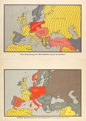
1914: Einkreisung der Mittelmachte durch die Entente - 1939/1940: Deitschland hat den Rucken frei [1914: The Central Powers Encircled by the Entente - 1939/1940: Germany Has Broken Free]
- Title:
- 1914: Einkreisung der Mittelmachte durch die Entente - 1939/1940: Deitschland hat den Rucken frei [1914: The Central Powers Encircled by the Entente - 1939/1940: Germany Has Broken Free]
- Alternate Title:
- 1914: The Central Powers Encircled by the Entente - 1939/1940: Germany Has Broken Free
- Collection:
- Persuasive Cartography: The PJ Mode Collection
- Creator:
- Adler, Ernst
- Other Creators:
- Haushofer, Albrecht; Hopker, Wolfgang; Michael, Horst; Link, Ulrich ("collaborators').
- Date:
- 1941
- Posted Date:
- 2017-04-14
- ID Number:
- 1301.01
- Collection Number:
- 8548
- File Name:
- PJM_1301_01.jpg
- Style/Period:
- 1940 - 1959
- Subject:
- World War II
Unusual Graphics/Text
- Measurement:
- 2 maps, each 17 x 27 (centimeters, height x width)
- Notes:
- This map is from the original, German-language version of a propaganda booklet later published in English by the "German Library of Information" in New York. For translations and more information about this controversial publication, see ID ##1302.01-.07, "The War in Maps" (1941).
For further information on the Collector’s Notes and a Feedback/Contact Link, see https://persuasivemaps.library.cornell.edu/content/about-collection-personal-statement and https://persuasivemaps.library.cornell.edu/content/feedback-and-contact
- Source:
- Wirsing, Giselher (ed.). 1941. Der Krieg 1939/40 in Karten [The War 1939/40 in Maps]. Munich: Verlag Knorr & Hirth (Munchner Neueste Nachrichten). Pp. 6-7.
- Cite As:
- P.J. Mode collection of persuasive cartography, #8548. Division of Rare and Manuscript Collections, Cornell University Library.
- Repository:
- Division of Rare and Manuscript Collections, Cornell University Library
- Archival Collection:
- P.J. Mode collection of persuasive cartography
- Format:
- Image
- Rights:
- For important information about copyright and use, see http://persuasivemaps.library.cornell.edu/copyright.
