Cornell University Library Digital Collections
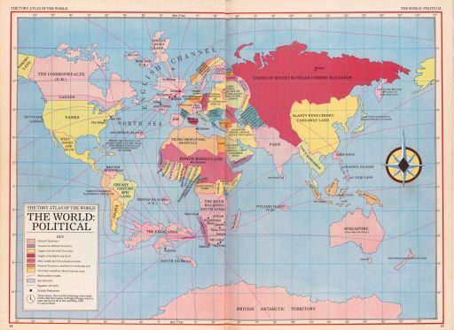
The Tory Atlas of the World - The World: Political

- Title:
- The Tory Atlas of the World - The World: Political
- Alternate Title:
- The Tory Atlas of the World
- Collection:
- Persuasive Cartography: The PJ Mode Collection
- Creator:
- Lloyd, John, Peter Fluck and Roger Law
- Date:
- 1985
- Posted Date:
- 2017-04-14
- ID Number:
- 1394.01
- Collection Number:
- 8548
- File Name:
- PJM_1394_01.jpg
- Style/Period:
- 1960 - Present
- Subject:
- Bias
Satirical
Ethnocentrism
- Measurement:
- 28 x 39 (centimeters, height x width)
- Notes:
- This map was included in a book published by the writers of "Spitting Image," a long-running satirical British television program. At the time of publication, 1985, memories of the 1982 Falklands War were still fresh, and the map attacks the Conservative government under Prime Minister Thatcher. The map is a riot of politically incorrectness, from "Greasy Gaucho Spic Land" (Brazil) to "Filthy Shoplifting Arabville" (North Africa) and "Slanty Eyed Chinky Take Away Land" (China).
For further information on the Collector’s Notes and a Feedback/Contact Link, see https://persuasivemaps.library.cornell.edu/content/about-collection-personal-statement and https://persuasivemaps.library.cornell.edu/content/feedback-and-contact
- Source:
- Lloyd, John, Peter Fluck and Roger Law. 1985. The Appallingly Disrespectful Spitting Image Book. London: Faber & Faber. Pp. 44-45.
- Cite As:
- P.J. Mode collection of persuasive cartography, #8548. Division of Rare and Manuscript Collections, Cornell University Library.
- Repository:
- Division of Rare and Manuscript Collections, Cornell University Library
- Archival Collection:
- P.J. Mode collection of persuasive cartography
- Format:
- Image
- Rights:
- For important information about copyright and use, see http://persuasivemaps.library.cornell.edu/copyright.