Cornell University Library Digital Collections
Pictorial map of the Middle Island of New Zealand: compiled from the latest government maps and statistical records
- Title:
- Pictorial map of the Middle Island of New Zealand: compiled from the latest government maps and statistical records
- Alternate Title:
- The Middle Island of New Zealand
- Collection:
- Persuasive Cartography: The PJ Mode Collection
- Creator:
- The New Zealand Graphic
- Other Creators:
- Publisher: N.Z. Graphic and Star Printing Works
- Date:
- 1898
- Posted Date:
- 2017-04-14
- ID Number:
- 2151.01
- Collection Number:
- 8548
- File Name:
- PJM_2151_01.jpg
- Style/Period:
- 1870 - 1899
- Subject:
- Advertising & Promotion
Pictorial
Unusual Graphics/Text
- Measurement:
- 77 x 57 (centimeters, height x width)
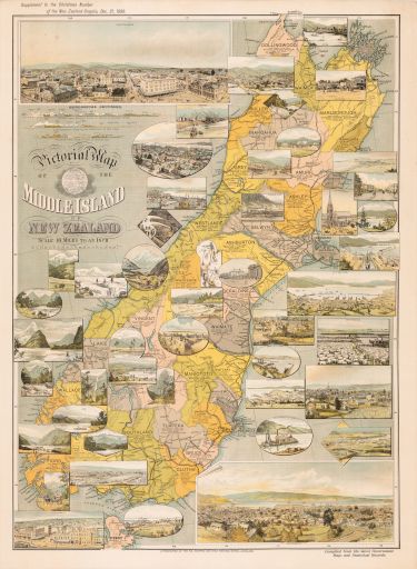
- Notes:
- An early promotional map of the Middle Island of New Zealand, with large birds-eye views of Christchurch and Dunedin. The most remarkable feature of the map is the extraordinary number of inset views (more than 40) of towns, ports, natural features and scenes of local activities: mountaineering, coaching, farming, mining, dredging, etc.
For further information on the Collector’s Notes and a Feedback/Contact Link, see https://persuasivemaps.library.cornell.edu/content/about-collection-personal-statement and https://persuasivemaps.library.cornell.edu/content/feedback-and-contact
- Source:
- The New Zealand Graphic, Supplement to the Christmas number, December 21, 1898. Auckland [N.Z.]
- Cite As:
- P.J. Mode collection of persuasive cartography, #8548. Division of Rare and Manuscript Collections, Cornell University Library.
- Repository:
- Division of Rare and Manuscript Collections, Cornell University Library
- Archival Collection:
- P.J. Mode collection of persuasive cartography
- Format:
- Image
- Rights:
- For important information about copyright and use, see http://persuasivemaps.library.cornell.edu/copyright.
