Cornell University Library Digital Collections
Kämpfe um den ostdeutschen Volksboden (Struggle for the East German Ethnic Lands)
- Title:
- Kämpfe um den ostdeutschen Volksboden (Struggle for the East German Ethnic Lands)
- Alternate Title:
- Struggle for the East German Ethnic Lands
- Collection:
- Persuasive Cartography: The PJ Mode Collection
- Creator:
- Putzger, F. W. (Friedrich Wilhelm), 1849-1913
- Date:
- 1936
- Posted Date:
- 2015-08-25
- ID Number:
- 1251.02
- Collection Number:
- 8548
- File Name:
- PJM_1251_02.jpg
- Style/Period:
- 1920 - 1939
- Work Type:
- atlases
- Materials/Techniques:
- printing
- Subject:
- Between the Wars
Ethnocentrism
- Measurement:
- 23 x 14 (centimeters, height x width)
- Notes:
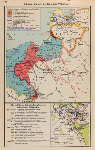
- This maps details "Losses due to the mandates of Versailles" and subsequent conflicts in the East (see Notes for ID #1205 "The Dismemberment of Germany").
The Putzger atlas dates originally to 1877. It "is considered 'the' historical school atlas of Germany and Austria and boasts one of the highest print runs in the world." (Herb 1997, 97).
For further information on the Collector’s Notes and a Feedback/Contact Link, see https://persuasivemaps.library.cornell.edu/content/about-collection-personal-statement and https://persuasivemaps.library.cornell.edu/content/feedback-and-contact
- Source:
- Putzger, F. W., In Pehle, M., In Silberborth, H., & In Iskraut, M. (1936). F.W. Putzgers historischer Schul-atlas. Bielefeld: Velhagen & Klasing. p. 120
- Cite As:
- P.J. Mode collection of persuasive cartography, #8548. Division of Rare and Manuscript Collections, Cornell University Library.
- Repository:
- Division of Rare and Manuscript Collections, Cornell University Library
- Archival Collection:
- P.J. Mode collection of persuasive cartography
- Format:
- Image
- Rights:
- For important information about copyright and use, see http://persuasivemaps.library.cornell.edu/copyright.
